
Quality Requirements Proposal for low bias GHCN Station Selection
Working DRAFT attention. Tuning of the requirements is expected if too stringent.

Objective
To establish rigorous standards for the selection of Global Historical Climatology Network (GHCN) stations to ensure accurate climate measurements devoid of urbanization and other biases. These requirements are motivated by the US Climate Reference Network (USCRN) key objectives, which include:
CRN1: Unchanging physical surroundings, particularly avoiding man-made structures.
CRN2: Locations representative of the climate.
CRN3: Long-term stability of the surrounding area.
CRN4: Spatial representativeness.
CRN5: Observations of high quality and stable settings.
The overarching goal is to achieve the highest level of accuracy and eliminate biases in climate measurements.

Our aim is to be equally or more stringent to achieve maximum accuracy by avoiding all known bias and error sources. The majority of these biases are related to landscape changes due to urban activities, which go far beyond the obvious city Urban Heat Island (UHI) effect. Any type of surrounding change leads to a change in temperature averages. This principle is fundamental to the NOAA PHA algorithm, which scans for ruptures in the time series that indicate station movement, altering the baseline. The same applies if the surrounding environment changes. Ideally, no change is allowed if the goal is to measure climate instead of landscape changes.
Flow down of CRN Criteria
Built-Up Area:
REQ-BA-01: Less than 1% built-up area within a 10 km radius.
REQ-BA-02: Less than 1% change in built-up area within a 10 km radius. Less than +5% new built-up in a 100 km radius.
REQ-BA-03: avoid mining and other industrial activities within 10k cell.
REQ-BA-04: the 10km radius BU growth 1975-2020 (GHSL P2023A) should ideally be zero.
Proximity to Oceans:
REQ-PO-01: No oceans within a ~2-5 km radius. Proximity to oceans can lead to sensor erosion, salt water spray contamination, and coastal erosion, which are not representative of land conditions.
Agriculture:
REQ-AG-01: Low agriculture within a 10 km radius.
REQ-AG-02: Less than 10% agricultural area within a 100 km radius.
Land Use and Infrastructure:
REQ-LU-01: No WW1/WW2 or similar type war damages within a 50 km radius. Generally, avoid countries with disrupted governments (communism, fascism, NS, dictatorship) in the last 100 years.
REQ-LU-02: Stations should ideally be based on CRN (Climate Reference Network) standards.
Historical and Social Context:
REQ-HS-01: Literacy rate in the surrounding area should have been high in 1930.
REQ-HS-02: The country of the station must have been a credible entity in terms of democracy, peace, and scientific excellence between 1920-2020.
Data Availability and Transparency:
REQ-DT-01: Raw data must be available from the country of origin and be inspectable/auditable.
REQ-DT-02: Adjustments to data must be explicitly clear and per station (e.g., Ekholm, SE). No cross-coupling between locations allowed.
REQ-DT-03: Raw data from the source must match GHCN raw data exactly.
Instrumentation and Measurements:
REQ-IM-01: Sensor information, operational times, and station pictures must be available.
REQ-IM-02: The entity responsible for taking measurements must be known and credible.
REQ-IM-03: Personnel operating the station must be trained and credible.
REQ-IM-04: Ideally, no changes in the sampling rate. May be unrealistic. TOB adjusting needed.
REQ-IM-05: Ideally, no sensor updates from the analog to digital era. May be unrealistic.
REQ-IM-06: Avoid high latitudes. Those areas are per default low quality. Adjustments needed are significant due to seasonal effects (TOB). The density of stations is low.
REQ-IM-07: Exclude above polar circle latitudes: such areas have almost no credibility.
Station Stability:
REQ-SS-01: No station relocations; ideally, the time series should remain uninterrupted.
REQ-SS-02: No stations in mountains or valleys to avoid terrain-induced biases. Stations in mountains and valleys are excluded to maintain consistency, as implicitly practiced by USCRN.
REQ-SS-03: Ideally ~100 years of data. Minimum from ~1945.
Urban Heat Island (UHI):
REQ-UHI-01: Zero UHI within a 20 km radius. BI should also be zero.
Weighting:
REQ-W-01: Max 100 km per station. Area weighting is a fallacy and not in line with good measurement practices which should prioritize accuracy and not amplify / inflate single remote stations. That would dilute quality measurements and prioritize error.
REQ-W-02: The ensemble shall be sampling based. Each stations should count once thus no overlap of the 100km cells. Minimum distance shall be 200 km.
Several requirements are in strong trade-off with each other. The 100-year requirement is not realistic without compromising all others. Therefore, stitching of anomalies will be needed, with each time period having a most suitable set of stations. The uninterrupted time series is also unrealistic. By default, all measurements are ruptured as the digital era started in 1980. The ocean distance criterion may exclude lighthouses, which were likely the most accurate places 100 years ago. Today, USCRN locations are by far the best. The final best set of requirements shall be derived after iterative test and analysis.
Good location example
A good example is USCRN Everglades City. The total area built is close to zero and stable at « 0.1%. That’s what we want.

Bad location examples
As mentioned, Europe is too urbanized for climate measurements. Shown below is just the UHI effect. As mentioned, ANY type of urban landscape altering increases surface temperatures as well. The Netherlands and Benelux regions are all fully biased and unfit for climate science

Generally, finding a compliant stations in core Europe will be very difficult, even if we


The Met Office UK's Chertsey station in Surrey is a prime example of violating nearly every weather monitoring requirement. In 2022, this mega city station was surrounded by low heat capacity metal and glass (PVs).
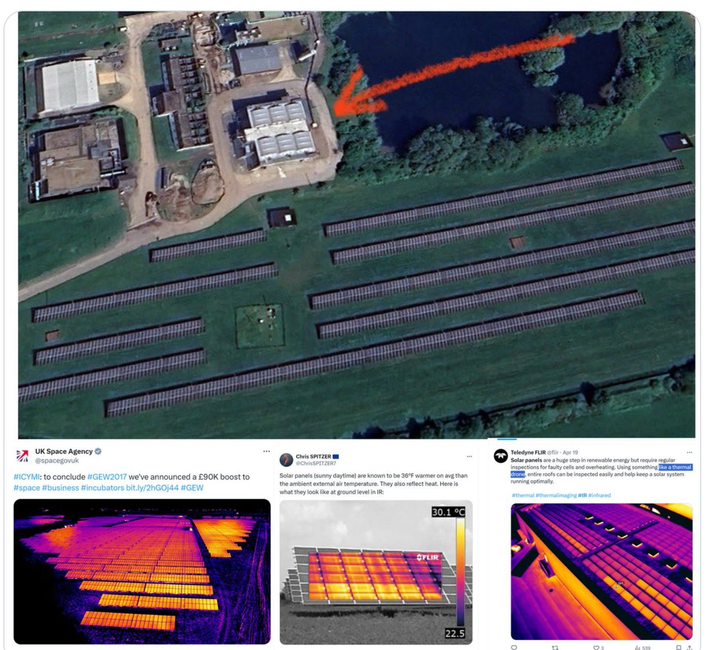
Unsurprisingly, the Met Office reported June temperature records in 2023 and 2024. The PVs emit the most heat around June, coinciding with peak solar forcing. This setup essentially makes PVs temperature monitors, not weather stations. The result? Predicted record highs. It would be insightful if Teledyne flir could deploy drone FLIRs during hot conditions and share the findings.

However, it's important to note that all weather stations in the Netherlands are non-compliant. It's simply not feasible to maintain compliance in the Netherlands any longer. This is something the Netherlands Meteorological Institute (KNMI) should recognize and acknowledge, rather than attributing the issue to emissions. Emissions are not the root cause of the problem. Urban Heat Island (UHI) effects are beneficial in most European locations, as they reduce heating costs and emissions. Only in extreme cases, such as Seville during summer, can UHI become problematic. However, for accurate climate measurements, UHI presents a significant challenge. These measurements cannot be effectively adjusted through software; a flawed measurement does not become accurate with software corrections. This is a fundamental principle of proper measurement practices.

Way forward
Implement the above requirements on the 30,000 GHCN stations to determine how many remain compliant. If no stations meet the criteria after this ideal scrutiny, some requirements may need to be relaxed or adapted. Overall, we want to avoid ending up with coastal stations only.
How will the expected list look? It will likely be limited to stations in the US, Sweden, and maybe a few other places. The majority of stations will be excluded, and rightfully so as they measure bias and not climate. The vast majority of survivor may be coastal like lighthouses. That’s not ideal as we want to measure land and not oceans nor the issues that arise in having sensors in such places.
Thx for your work keep posting on SS.
Reading your X posts, still like the overview on SS